DENVER — After a near 70 degree day on Wednesday, big changes came to northeastern Colorado, with snow and very cold temperatures.
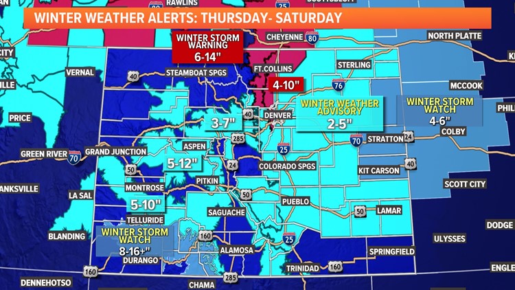
A Winter Storm Warning is in place for Boulder, Fort Collins and most of the foothills west of Interstate 25 for Thursday night and Friday for a Thanksgiving weekend snowstorm. Denver and the rest of the metro area are under a Winter Weather Advisory starting on Thursday evening and running until early Saturday morning.
Some foothill locations could see more than a foot of snow, while most of the Denver area will see anywhere between 1 and 8 inches. Yes, that's a wide range, depending on your exact location. We've got more details in the snow totals section below.
Snow developed from north-to-south after dark on Thanksgiving night, first reaching places like Fort Collins, Greeley and the northern foothills. In Denver, the snow began between 6 and 11 p.m. on Thanksgiving night.
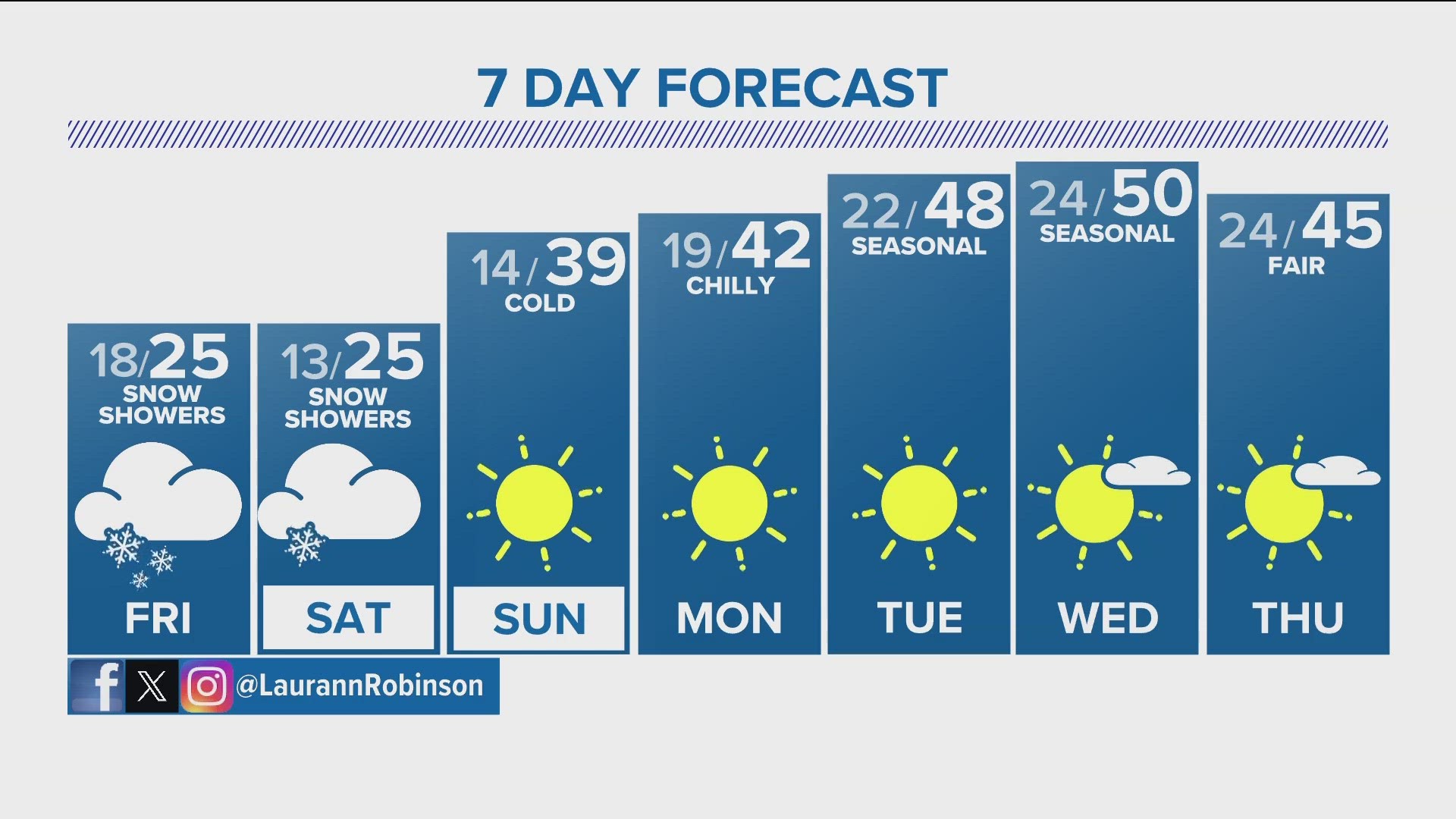
The snow will likely stick around all day Friday, along with bitterly cold temperatures. Highs will top out in the 20s on both Friday and Saturday in Denver.
The snow will probably be heaviest overnight Thursday into Friday. During the day Friday, it'll mostly be a lighter snow that could linger into early Saturday. By midday Saturday, the accumulating snow should be done across northeastern Colorado. Light flurries on Saturday will probably give way to some bits of sun on Saturday afternoon and evening.
By Sunday, sunny but chilly weather should start the melting process, and it'll gradually warm up and stay dry through most of next week.


Thanksgiving weekend snow totals
As far as totals are concerned, the foothills in both Larimer and Boulder counties will probably wind up with the highest totals from this storm. Areas like Boulder, Fort Collins, Estes Park, Lyons, Nederland, and Allenspark could see 6 to 14 inches of accumulation by the time the snow finally ends Saturday.
In the Denver metro area, areas along and east of I-25 may only get 1 to 3 inches of accumulation, while amounts significantly increase west of I-25. Western Denver area suburbs like Golden, Arvada and Morrison will probably pick up between 3 and 6 inches of snow. Downtown Denver will likely see 2 to 5 inches of accumulation from this long-lived system.
The plains north and east of the urban corridor could also see a widespread 4 to 8 inches of snow, with some wind, as well.
As usual, there are some changes and differences in the computer forecast models on snowfall totals, so stay with 9NEWS for the latest forecast.


Colorado snow travel impacts
While Thanksgiving itself looks mostly OK until well after dark, there will be some significant travel issues across most of northeastern Colorado on Friday, specifically. There'll likely be at least some delays at Denver International Airport on Friday and maybe into early Saturday.
Roads will probably be snow-covered around the Denver area, as will the major interstates (I-25, I-70, and I-76) across northeastern Colorado all day on Friday. If you can, you might want to plan on driving on Saturday or Sunday instead.
There could be some lingering issues on Saturday as well, but the accumulating snow should be mostly or entirely done by sunrise on Saturday.
Cold temperatures
Finally, this week's storm could bring northeastern Colorado its coldest air so far this season. Highs on Friday and Saturday in Denver will probably be stuck in the low-to-mid 20s, with overnight lows (depending on cloud cover) dropping into the lower teens or perhaps even the single digits on Saturday and Sunday mornings.
Temperatures rebound into the 40s for Sunday and Monday, and we'll likely be back in the 50s by the middle of next week.


SUGGESTED VIDEOS: Colorado Climate